


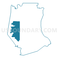
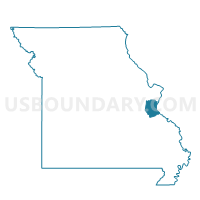
Ware Voting District, Jefferson County, Missouri
About
Outline

Summary
| Unique Area Identifier | 608865 |
| Name | Ware Voting District |
| County | Jefferson County |
| State | Missouri |
| Area (square miles) | 56.36 |
| Land Area (square miles) | 56.31 |
| Water Area (square miles) | 0.05 |
| % of Land Area | 99.90 |
| % of Water Area | 0.10 |
| Latitude of the Internal Point | 38.23779830 |
| Longtitude of the Internal Point | -90.67761400 |
Maps

Graphs
Select a template below for downloading or customizing gragh for Ware Voting District, Jefferson County, Missouri


Neighbors
Neighoring Voting District (by Name) Neighboring Voting District on the Map
- Cedar Hill Lakes Voting District, Jefferson County, MO
- Cedar Hill No. 1 Voting District, Jefferson County, MO
- Cedar Hill No. 2 Voting District, Jefferson County, MO
- Fletcher Voting District, Jefferson County, MO
- Grubville No. 1 Voting District, Jefferson County, MO
- Grubville No. 2 Voting District, Jefferson County, MO
- Hillsboro P-1 Voting District, Jefferson County, MO
- Lake Tishomingo Voting District, Jefferson County, MO
- Valle No. 2 Voting District, Jefferson County, MO
- Vineland No. 2 Voting District, Jefferson County, MO
Top 10 Neighboring County Subdivision (by Population) Neighboring County Subdivision on the Map
- Meramec township, Jefferson County, MO (18,192)
- Valle township, Jefferson County, MO (15,153)
- Central township, Jefferson County, MO (13,907)
- Big River township, Jefferson County, MO (6,597)
Top 10 Neighboring Place (by Population) Neighboring Place on the Map
Top 10 Neighboring Unified School District (by Population) Neighboring Unified School District on the Map
- Northwest R-I School District, MO (45,694)
- Hillsboro R-III School District, MO (21,291)
- De Soto School District, MO (17,199)
- Grandview R-II School District, MO (4,814)
Top 10 Neighboring State Legislative District Lower Chamber (by Population) Neighboring State Legislative District Lower Chamber on the Map
Top 10 Neighboring State Legislative District Upper Chamber (by Population) Neighboring State Legislative District Upper Chamber on the Map
Top 10 Neighboring 111th Congressional District (by Population) Neighboring 111th Congressional District on the Map
Top 10 Neighboring Census Tract (by Population) Neighboring Census Tract on the Map
- Census Tract 7005.02, Jefferson County, MO (5,812)
- Census Tract 7011.02, Jefferson County, MO (5,792)
- Census Tract 7004.01, Jefferson County, MO (4,746)
- Census Tract 7011.01, Jefferson County, MO (4,116)